Last update : 17/12/2002

Main menu

 The authors

  • Coordination team (the core team)
  • The GUI and the 3D display
  • Exchange format
  • Data optimizer

  •  Available theme :

  • Bitmap wrapping
  • 2D graph wrapping
  • Toponymy in 3D
  • Oriented 3D relief model
  • Furtive flight at sight
  • Fluid network
  • Aerial power cable
  • Underground gallery modeling
  • Building and roof
  • Land line wrapping (OS 1:10000 scale map)
  • Flooding propagation
  • River bed display on DTM
  • Geological cross section
  • Underground site modeling
  • Pollution propagation
  • Fire propagation modeling
  • Itinerary under constraints
  • GSM Follow-up of vehicles
  • Photos Database
  • Discreet simulation on DTM
  • Vegetal growth modeling

  •  Principle used :

    Quaternion

     Multi-thematic :

    Interfacing example

     Links :

  • Programming : All the languages.
  • GIS and informatic : jobs, lessons, bibliography.
  • Formations.
  • Linux : to the world of the penguin.
  • Various : Other links.

  • Project realized by the year 2001 - DESS AIST ( Paris VI - ENSG) - France

    "Computing applied to the Earth Sciences"

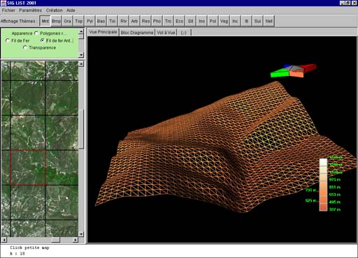
    IHM principale et MNT version fil de fer

    Why this Web site ?


    The display of spatial in 3D and the GIS - Geographic Information System - are in full rise.

    This site is aiming to highlight the 'savoir-faire' of the actors-students, having developed this project.

    It comprises the Geomatic and GIS principle taught at the DESS "computing applied to the earth Sciences", du Laboratoire d'Informatique des Sciences de la Terre (L.I.S.T.),University Pierre and Marie Curie, Paris VI, France - National School of Geography.


    Project Description


    This project comprises the development of 3D Geographic information System core.

    It has been realized in 5 weeks full time, with 24 teams composed of 2 to 4 students, so 72 peoples all linked on the same project.

    The Digital Terrain Model (DTM) characteristics are as follow :

    21 themes were displayed using the same interface.

    It has been developed using JAVA and the library JAVA3D.

    Java3D de SUNJava3D de SUNJava3D de SUN


    Project organization


  •  1 team to coordinates the overall project, GUI and the 3D :
  •  1 team to optimize the project :
  •  1 team for the exchange format :
  •  21 team responsible for the 3D display of 21 themes :

  • Principles used in the project


    Within the project, many mathematical tools were applied :


    Interfacing example


    Several screen shot are available here displaying the result of various themes.